Locating a National Collection - Hollar 1660
This map locates the places illustrated on an etching from George III's Topographical Collection, held at the British Library. It depicts prominent locations including castles, bridges, and churches, providing a ‘tour’ of 17th-century landmarks and places of political importance around England and Wales.
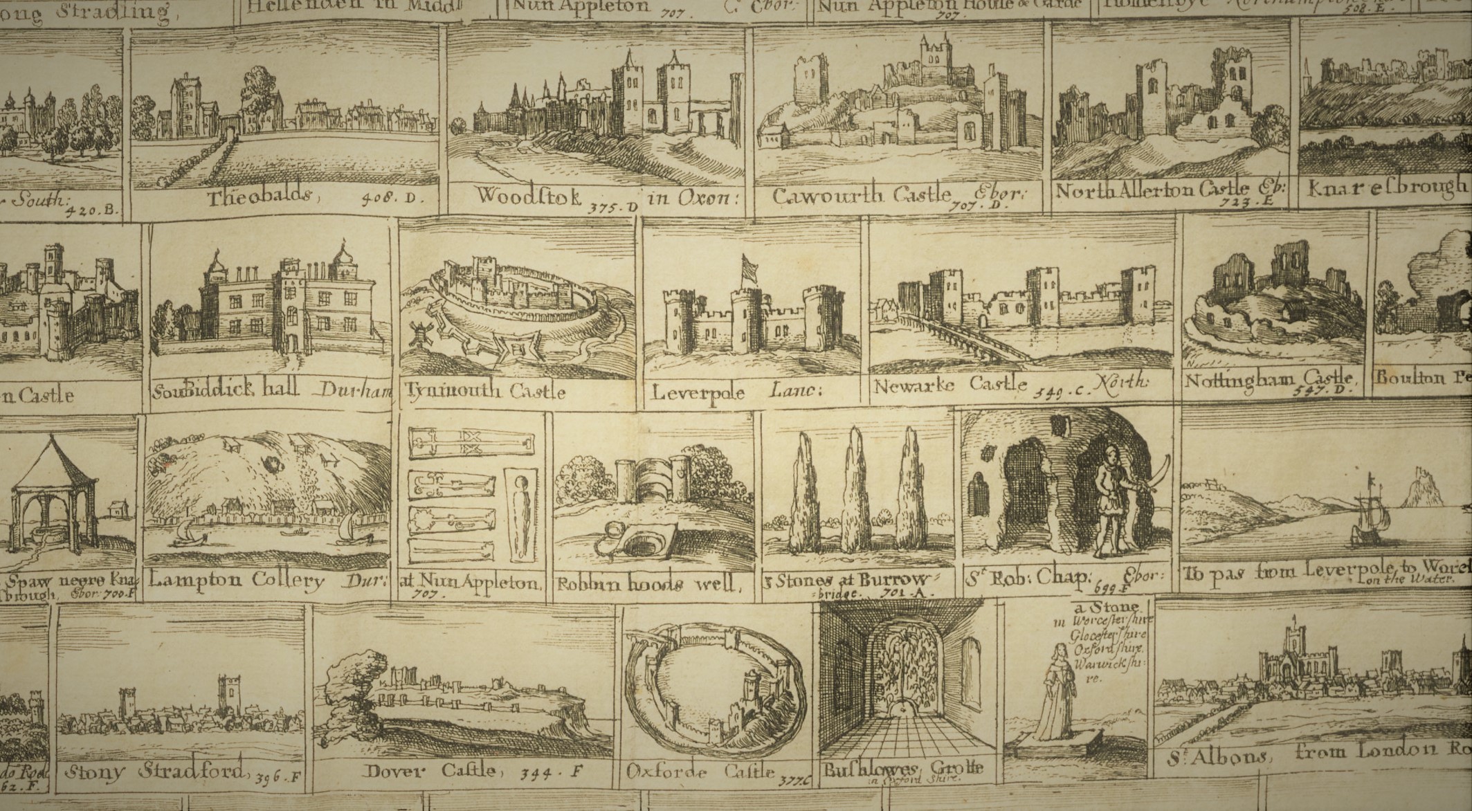
Made by Wenceslaus Hollar in about 1660, it was perhaps intended to be bound with a future edition or reprint of Camden's Britannia. Camden's work was first published in 1586, a topographical and historical survey intended to "restore antiquity to Britaine, and Britain to his antiquity". The 1607 edition was the first to include county maps, based largely on the work undertaken by Christopher Saxton in the 1570s. Saxton's astonishing maps can be seen online in the British Library's 'Burghley Atlas'.
Hollar's images are annotated with page numbers relating to the 1637 edition of Britannia indicating where descriptions of the places illustrated can be found. The full image can be seen here, and an itemised list of the drawings can be examined here.
Using the Map
Here are some ideas for things you can try to do with this map:
- Use the Clusters and Heatmap visualisation modes (click the 'folded map' icon on the right of the map) to identify hotspots of Hollar's activity.
- Click the filter icon in the top left and scroll over the map to see the locations of illustrated bridges. These indicate a likely route taken by Hollar.
- Use the search box at the top of the map to find Nun Appleton in Yorkshire. Examine Hollar's illustration of gravestones from the former priory there, and use the Related Records link to see the Historic England Listed Building entry for the country house built there in the late 17th century.
- Look at Hollar's illustrations of castles: these can be found by filtering by 'Type', clicking on a filtered marker, and then clicking on the icon that appears over the image in the popup box. Can you identify any castles that appear to have been drawn before being slighted in the Civil War?
Making the Map
One of the challenges for this project was to provide a means of visualisation for datasets generated using Recogito, which has become a standard tool for the annotation of images and texts in the GLAM sector (Galleries, Libraries, Archives and Museums). Using Recogito's IIIF capability, an image of Hollar's etching was first annotated and his drawings geolocated by David Cant and Tamsin Braisher (two volunteers working on the Viae Regiae public history project). The resulting dataset was then enriched, using Locolligo to make additional links (both manually and automatically based on proximity) to type vocabularies, Wikipedia, and other online cultural heritage resources.